Chapter 1: Lowell of the South
There are no lakes in any part of the region under consideration except a few near the coast, a position which renders them of no value as regards water-power.
—George F. Swain (1885)
After months of planning and recovery from an industrial accident, John Muir began his southern walking tour in late 1867 at an unusual and critical turning point in the region’s history. Well in advance of his better-known and published experiences of his first summer in California’s Sierra Mountains, Muir passed through Georgia in the wake of the American Civil War on his “thousand mile walk” from the Midwest to the Gulf of Mexico. After arriving in Gainesville, Georgia, Muir spent September 24 “sailing on the Chattahoochee” with an old friend from Indiana. While cruising the “first truly southern stream” he had ever encountered, the two men set about “feasting” on ripe wild grapes that dropped into the unencumbered upper Chattahoochee River. Muir and his host followed the apparently free-flowing river’s cue and currents and discovered masses of grapes floating effortlessly in slow churning “eddies along the bank.” Other enterprising men working with the river from boats and the shore easily collected the grapes from these pools where the river’s current slacked. Muir enjoyed some of the delicious grapes right out of the river, as well as the muscadine wine they produced. “Intoxicated with the beauty” of the river’s banks and intrigued by what the banks farther down the river might look like, Muir briefly contemplated traveling the Chattahoochee by boat to the gulf. However, he opted to forgo the water route in favor of overland travel to really see the southern landscape, and eventually, he reached Augusta by foot.1
In deciding to walk and record his observations, Muir contributed to a set of social and economic assumptions about the American South. John Muir wanted to disengage from an “entangling society,” according to environmental historian and biographer Donald Worster, but he did not avoid journaling and judging the region as a rural and uncivilized backwater.2 Furthermore, Muir encountered a postbellum South that remained—like the majority of the nation at the time—primarily an agricultural region with wild margins that lacked the pristine wilderness usually associated with the Sierra Club’s first president.3 In his travels across the Chattahoochee, Oconee, and Savannah River valleys, Muir “zigzagged … amid old plantations” and encountered former slaves working and harvesting low-hanging bolls in cotton fields for wages. Muir also encountered the “northern limit” of the longleaf pine (Pinus palustris) ecosystem. The trees fascinated Muir: “sixty to seventy feet in height, from twenty to thirty inches in diameter, with leaves ten to fifteen inches long, in dense radiant masses at the ends of the naked branches.” The cotton fields, African American laborers, plantations, and timber all pointed to a real, antebellum past powered by human and animal muscles sustained by soil. Muir described these social and economic realities and perpetuated a historical narrative of life and labor in the American South that overlooked critical components of the region’s environmental, industrial, and organic energy history.4
Before the Civil War, Piedmont southerners had already begun to move beyond agricultural production and muscle power, and they relied on southern rivers and renewable energy to do so. When Muir reached Augusta and the fall line—the point where the Coastal Plain and Piedmont merge and easy upstream navigation ends—he did not say anything about the Old South’s antebellum textile mills or industrial artifacts. Nor did he describe the 1,000-foot-long rock dam that diverted the Savannah River’s current from a series of rocky shoals into a maze of linear waterpower canals. Augusta’s industrialists had re-created a version of the New England Waltham-Lowell system that Henry D. Thoreau described in A Week on the Concord and Merrimack Rivers (1849). Augusta’s system never reached the scale Thoreau found during his New England paddling trip, and the New England factory system and mill towns were, of course, rare. Scattered grist- and sawmills in the Savannah River’s creeks and tributaries—such as William Gregg’s Horse Creek valley mills—were more common throughout early America, including the Southeast. Regardless of scale and technological diffusion, Augusta’s system captured an organic and renewable energy source, reorganized modes of production, required external collaboration, and altered the river’s environment. And from this perspective, Augusta looked a lot like a New England mill village in an agricultural nation.5
The upper Chattahoochee and Savannah Rivers did flow freely through Blue Ridge and Piedmont agricultural landscapes with “intoxicating banks” in the nineteenth century. Downstream at the fall line, however, Old South entrepreneurs in towns and cities such as Columbus and Augusta had already erected diversion dams, created small artificial ponds, and laid the foundations for an industrial New South upon the banks of southern rivers during the 1840s. By focusing on the natural history and agricultural dimensions of the southern landscape, Muir obscured the early industrial legacy of the energy-water nexus in the American South.6
Throughout the nineteenth century—and in the centuries before—Savannah River valley inhabitants depended on the river to survive. As John Muir traveled leisurely through multiple southern river valleys, he passed through a peopled and working landscape that had been shaped as much by Indian, African, and European hands as it had been shaped by droughts and floods. All of these human and natural influences crafted a Savannah River valley that was an agricultural and industrious place before the American Civil War.
Antebellum Georgians, South Carolinians, and their industrial allies began a process that fundamentally transformed the region’s free-flowing rivers into a collection of pools and reservoirs encumbered by dams or channeled in new directions to generate industrial energy and remap social power. The Southeast was rich in organic energy—soil, timber, and wildlife—but lacked abundant and easily transferable mineral fuels—coal and oil—required to generate energy. Participants in America’s famed market revolution, however, brought organized capital and mainstream dams south in the 1840s. Entrepreneurs amassed private investors’ capital or entered into public-private partnerships to build diversion dams along the region’s fall-line urban centers, including Columbia (S.C.) on the Congaree River and Augusta on the Savannah River, to fill canals and supply muscle-powered factory laborers with water and renewable industrial energy.
Water and power have been linked for a long time in the American South.7 Muir may have observed Augusta’s emerging hydraulic waterscape, and had he decided to float the Chattahoochee River from the Georgia mountains to the Gulf of Mexico, he would have discovered similar infrastructure in Columbus. Aside from this speculation, Muir did describe an agricultural landscape, and in so doing, he missed key physical industrial artifacts that were the building blocks of the American South’s modern waterscape and political economy. As he descended the Savannah River valley, Muir would eventually encounter the spirit responsible for transforming antebellum waterpower into “New South” hydroelectric power, a process that built a water and power nexus with alacrity.
The Savannah River Basin
The Savannah River watershed encompasses approximately 10,500 square miles in Georgia, South Carolina, and North Carolina. Like a funnel, the watershed consolidates water seeping from underground springs and rain that falls on the ground and drains from northwest to southeast. Water flows quickly to the Atlantic Ocean, since this watershed travels the shortest distance from mountains to sea of any mountain-to-sea river basin in the southeastern United States. Blue Ridge Province streams and creeks descend from Western North Carolina’s ancient mountains (5,500 feet above sea level) to the Piedmont Province (elev. 1,000 ft.). Gathering speed, the rugged Southern Appalachian headwater streams give rise to Georgia’s Tugaloo River and South Carolina’s Seneca River before these two form the 300-mile-long Savannah River. Serving as the dividing line between Georgia and South Carolina, the Savannah River then pushes through the Piedmont and over rocky shoals before cascading over the fall line at Augusta, Georgia (elev. 200 ft.). Below this city, the rocky Blue Ridge and Piedmont clays give way to the Coastal Plain’s softer alluvial soils. The gradient change causes the rushing Savannah River to decelerate and slowly twist back upon itself to form serpentine “oxbows” throughout the remainder of the river’s journey to Savannah, Georgia (elev. 42 ft.), and the Atlantic Ocean.
Intense geological energy and force created the southern landscape and the Savannah River watershed more than 200 million years ago, when what are now the North American and African continental plates repeatedly collided with each other before separating for the last time. These faulting and thrusting collisions—whereby the plates slid under or over each other—created uplift in the earth’s crust and resulted in the formation of the Blue Ridge Mountains, which some geologists think may have been as tall as the Rocky Mountains. Over the following millions of years, erosion—rain, snow, ice, and wind—slowly whittled the Blue Ridge, contributing to creation of valleys that drained through the rolling hills of the southern Piedmont and the more moderate Coastal Plain gradients to the Atlantic Ocean, or drained through the ridge and valley to the Gulf of Mexico.8 The tectonic forces were important for creating deep valleys and narrow gorges—important landforms that can constrict stream flow—but these actions alone could not form lakes as found elsewhere in North America.
Glacial movement in conjunction with tectonic forces carved the landscapes necessary for natural lakes in other parts of North America, but these combined forces did not sculpt a southern landscape to create natural lakes. During the great Ice Age of the Pleistocene epoch (20,000 to 9,000 years ago), a giant ice sheet stretched from coast to coast but never advanced from the polar north beyond present-day Ohio. Nearly three miles thick, it sliced valleys and pushed soil to build low ridges. As the giant ice sheet began to recede and melt 16,000 years ago, it left behind midwestern and New England waterscapes pocked with natural lakes from Minnesota to Maine and flooded the Mississippi River valley with meltwater. Like tectonic forces, the glacial retreat did not scrape the southern landscape and leave behind a waterscape of natural lakes.9 Geological and climatic events were not the only conditions that influenced the form and composition of the southern landscape. People also shaped the Savannah River valley for thousands of years before any lakes or artificial reservoirs appeared on the landscape.
William Bartram, the American South’s best-known southern naturalist, provided the most complete picture of the Savannah River valley, having traveled from the Atlantic port of Savannah throughout the valley’s Piedmont and Blue Ridge headwaters between 1773 and 1775. Endowed with a gifted botanical eye and an artful pen, Bartram observed how planters organized the valley’s land, water, and human energy resources.10 African slavery—initially outlawed in colonial Georgia before legalization in 1751—made it easier for Euro-Americans to capitalize on the valley’s natural resources and enabled Georgians to directly compete with South Carolina in production of agricultural and export commodities such as rice.11
Bartram called on one diversified South Carolina plantation, located near the present-day town of Bordeaux but now partially under Clarks Hill’s reservoir, which was “situated on the top of a very high hill near the banks of the river Savanna.” From Frenchman Mons. St. Pierre’s house, Bartram looked down and across fields of corn, rice, wheat, oats, indigo, and sweet potatoes on “rich low lands, lying very level betwixt these natural heights and the river.” Other reports suggest Bordeaux—located about 3.5 miles from the Savannah River in McCormick County, South Carolina—was primarily inhabited by up to 700 Huguenot transplants who attempted silk cultivation and wine production. But after the American Revolution, the region turned to cotton as a staple crop. Bartram provided no sense of the size of this or other plantations, but these settlements required more than the river valley’s soil and free-flowing water to survive.12 On another stop, Bartram called on one slave owner downstream from Augusta who deployed African labor into the “ancient sublime” longleaf pine and cypress forests. There they cut and prepared timber for export downriver to Savannah and beyond to the “West-Indian market.” Euro-Americans and African slaves consistently cultivated the valley’s rich soil and water resources for international markets, and those basic resources became significantly more valuable after the American Revolution.13
Once European colonists arrived in the Savannah River valley, developments designed to reap southern rivers’ currents began to follow patterns familiar in other regions, such as New England. In the colonial and early national periods, private investors improved water resources at specific sites, constructing single mills or small factories alongside natural waterfalls or shoals. Millwrights undertook similar projects in watersheds adjacent to the Savannah. Like Native American anglers who congregated around rocky shoals to capture fish and like farmers who planted the valley’s mineral-rich bottoms and floodplains, Euro-American mill builders utilized specific sites and the river’s energy to serve limited geographical markets.14
Well into the antebellum era, private individuals and investors continued to harness the Savannah River’s water energy to power gristmills, lumber mills, and cotton gins. Planters such as James Edward Calhoun, who owned and operated the Millwood Plantation, erected low dams to drive mills and machinery. James, the cousin of South Carolina’s John C. Calhoun, who is remembered for steering the nullification and state’s rights crisis of 1833 prior to the American Civil War, owned property that stretched for seven miles and covered more than 10,000 acres on both sides of the Savannah River in Abbeville (S.C.) and Elbert (Ga.) Counties. This property included small dams and diversion structures that channeled water to small mills that sat on riverbanks. Unlike some of the plantations Bartram visited high on bluffs above the river, Millwood sat in the Savannah River’s floodplain below the mouth of the Rocky River and about sixty miles upstream from Augusta. Calhoun’s many small diversion dams, which did not run from bank to bank, simply redirected a portion of river to run multiple mills and assorted machinery starting in 1832, and by 1850, mill manager Delancy Chisenhall produced cornmeal, wheat flour, lumber, and leather for Calhoun.15
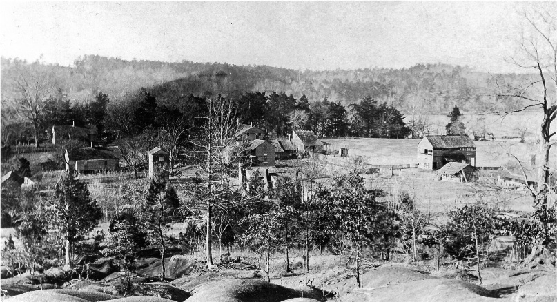
Millwood Plantation, n.d. (photographer unknown). In Sharyn Kane and Richard Keeton, Beneath These Waters: Archeological and Historical Studies of 11,500 Years along the Savannah River (Savannah, Ga.: U.S. Army Corps of Engineers and the Interagency Archeological Services Division, National Park Service, 1993). Image from Richard B. Russell Study Files, University of Alabama Museum, Moundville.
Before the Civil War, Calhoun diversified his crops and succeeded because he ordered the energy of slaves, tenants, and soil to produce the plantation’s primary product—cotton—in addition to peas, corn, turnips, and oats. Calhoun’s diversification may have been an aberration in comparison with other plantation owners in the region, but his and his neighbors’ staple cotton crop anchored central Georgia’s and South Carolina’s economy. As cotton replaced tobacco, the influence of upriver villages such as Petersburg, Georgia, declined. Throughout the region, planters like Calhoun often erected cotton gins and gristmills and allowed local farmers to use the facilities on a cash or exchange basis.16 These operations remained local affairs and only began to change as planters cultivated a new variety of cotton, developed new ginning and power sources, and found themselves plugged into the nineteenth century’s growing global commodities exchanges.
Textile professionals favored the high-quality, long-staple Sea Island cotton produced on the coast, but farmers and planters in the southern Piedmont could not grow Sea Island cotton. This dynamic soon changed. The convergence of a cotton variety (short-staple), improved ginning technologies, and access to international markets contributed to an explosive moment for antebellum Piedmont cotton production.17 But the increased output also led to soil depletion, erosion, land consolidation, and outmigration. Farmers—those who owned no or few slaves—who could not keep up with soil improvement or land rotation cycles or purchase new land and slaves moved farther west into Alabama and Mississippi. Between 1810 and 1850, there was a massive white exodus and a corresponding increase in black labor throughout South Carolina’s and Georgia’s Piedmont. Some of those planters who remained assumed leadership positions in the region, and those who continued to farm in the bottomlands—the agricultural reformers like Calhoun—enjoyed greater returns on their crops because of direct links to markets in Augusta and Savannah.18
Calhoun’s access to the Savannah River facilitated his grasp of power in the local marketplace, but it also linked him to the region’s unpredictable water flows. The summers between 1832 and 1834, according to his journals, were particularly dry. Calhoun’s cotton and corn suffered ten weeks without rain from May through August 1832. The Savannah ran “unusually low and for a long time” in the fall of 1833, and Calhoun again was “wanting rain” to sustain his cotton in October 1834.19 When the Savannah River was flowing, Calhoun’s hired white and slave laborers could manufacture material items necessary to keep the whole operation running, but they also constantly reacted to the river’s behavior. Flooding—or “freshets”—damaged floodplain fields, and the river rose “as high nearly as in Dec. 1831 which exceeded any Freshet for many years before.”20 Calhoun repeatedly contracted with individuals to reinforce and maintain his dams because he was “uneasy about … [their exposure] to the whole force of the River during freshets.” Calhoun’s personal proto-industrial activities did not necessarily contribute to a southern market revolution on a scale equivalent to what emerged in Massachusetts’s Lowell mills. But his experience illustrates the complex quality of his relationship with capital and the Savannah River. The waterway could run dry or flood, and both events threatened to ruin his financial investments. Calhoun—a man rich in real property but perpetually short of cash—apparently dreamed of building a large textile mill on the Millwood site. But he ultimately left that task to downstream investors and “men of capital” with access to deeper pockets.21
Lowell of the South
By the nineteenth century, the Savannah River valley looked like other American river valleys with small agricultural and growing industrial communities. The Savannah River had flowed freely until the decades before the American Civil War, and the Augusta Canal diversion dam signaled the beginning of a new relationship between water and power—and a new organic energy regime—in the southern Piedmont.
The city of Augusta, affectionately anointed “the Lowell of the South” by the Augusta Chronicle’s editors, successfully redirected the Savannah River’s energy-rich current on a much larger scale than Calhoun alone could have ever achieved. Augusta’s prominent city boosters secured the local political will, the necessary financial resources, and the appropriate technological advice to begin construction on the Augusta Canal in the 1840s less than 100 miles downriver from Calhoun’s Millwood Plantation.22 Georgia and South Carolina generally lagged behind other states during the canal-building era when compared with New York (Erie Canal, 360 miles long) or Maryland (Chesapeake and Ohio Canal, 185 miles long). Georgians and South Carolinians only constructed a handful of transportation canals: the 22-mile-long Santee and Cooper canal (constructed between 1793 and 1800); the 15-mile coastal Savannah-Ogeechee-Altamaha canal (1825–30); and a 12-mile canal connecting the Altamaha River with the port at Brunswick, Georgia (1834–54). All of these canals suffered for financial reasons and as a result of railroad competition.23 However, the Lowell of the South was motivated by this canal-building era and the original Lowell’s emergence as the epicenter of North American textile manufacturing.
Augustan Henry Harford Cumming merged the political, financial, and technological powers necessary to move the Augusta Canal from an idea in the 1830s to a reality in 1845.24 More than anything, Cumming wanted to anchor Augusta’s mercurial economy and to reverse the city’s dependence on northeastern cities and the southern ports of Savannah and Charleston. Cumming sensed that Augusta could compete with Lowell, where investors built twenty-eight water-powered mills and massed 8,000 workers to operate 150,000 spindles and 5,000 looms by 1839.25 Cumming and other regional entrepreneurs like South Carolinian William Gregg reasoned, Why send raw cotton to New England when it could be processed closer to the fields where it was harvested? Gregg had toured Lowell in 1844 and decided to mimic the system in the Horse Creek valley ten miles east of Augusta on a Savannah River tributary in South Carolina. Operations at the Graniteville Manufacturing Company and mill village where Gregg employed over 300 white workers to operate 9,000 spindles and 300 looms eventually began in 1849.26 In the years leading up to Gregg’s decision to build his first mill, people like Cumming understood that the region’s large pool of restless and landless labor—a perceived problem in its own right—could be redirected from farms to the factories fueled by water.
In the wake of the 1830s national financial panic and regional soil erosion, many Georgia and South Carolina farmers began to flee the state for the “black belt” soils of Alabama and points west. This exodus threatened the region’s political economy.27 To stop the hemorrhaging, local leaders advocated for investment in additional projects and a shift to a nationalized and diversified commercial economy. Augusta’s Henry H. Cumming advocated on these lines of reasoning and believed new railroads would ultimately favor cities like Augusta. All of these factors—access to raw materials, local labor, and transportation links to international markets—led Cumming, Gregg, and other men of capital to employ the Savannah River valley’s water to drive a diversified commercial economy during the nineteenth-century southern market revolution. Antebellum southerners were beginning to balance agriculture with industry—within an organic energy regime—long before Muir passed through the region in 1867.
In Cumming’s mind, the Augusta Canal could tame a short section of an unpredictable river and fuel factories while achieving two other connected goals. First, as a transportation conduit, the canal provided a limited bypass through the fall line. The canal was a limited navigational solution because boats could enter the canal upstream of Augusta but could not exit the canal into the Savannah River below Augusta. As a navigational waterway, the canal facilitated movement of agricultural products between Augusta and upstream communities. Once goods arrived in Augusta, they were off-loaded, processed in Augusta, and reloaded onto Savannah-bound riverboats or Charleston-bound railroads. Traveling the upper Savannah River’s reaches by boat was daunting; shoals, rocks, and unpredictable water levels made travel hazardous at best. Despite many sources of water such as springs and rainfall, seasonally fluctuating water flows hampered commerce on nearly every river in the American South. Rivers typically ran low in the spring and summer and could rise with autumn tropical storms and winter rains. Not enough rain made navigating the upper Savannah River’s shoals difficult with cargo-laden boats, and too much water could turn rivers into torrents.
The Augusta Canal provided seven miles of safe passage through the Savannah River’s fall line and around one of the river’s longest sets of shoals regardless of water levels. The technology necessary for this endeavor, as for canals in other parts of the American South, came from outside the region. A community of transnational engineers, including Loammi Baldwin Jr., Charles H. Bigelow, James Bechno Francis, and William Phillips, who were associated with designing water infrastructure in Lowell and elsewhere helped build the antebellum South’s water schemes to provide water security.28
The engineers and individuals like Cumming who contributed to the southeastern hydraulic waterscape also demonstrate what the market revolution and transition to capitalism looked like in one part of the American South. Scholars have typically reduced the market revolution to a conflict either between the interests of coastal merchants and yeoman famers or between cotton planters, poor yeomen, and slaves.29 The Augusta Canal’s example illustrates that middle class, urban professionals—like Cumming and Phillips—do not fit into those categories. According to historians Tom Downey and Bruce Eelman, these individuals were the men of capital who shaped the southern waterscape and the antebellum South’s diversified market revolution. “Men of property”—those elite individuals who owned slaves, stands of timber, or small mills throughout the South—represented one layer of southern industrialists who increasingly ceded political power in the late nineteenth century to the new group of capitalists. The men of capital—like Cumming and his South Carolina neighbor William Gregg—symbolized the new southern industrialist mentality that gained significant political clout before the American Civil War. On the war’s eve, the valley’s political economy had begun to shift from favoring men of property—who were rich in slaves and real estate—to include men of capital who pooled resources and built incorporated institutions like mills and factories.30
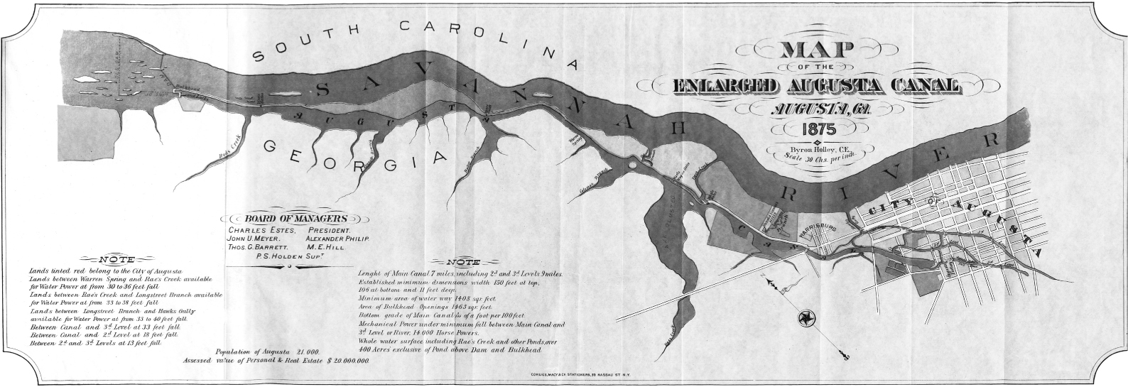
The Augusta Canal, 1875. The diversion dam channeled the Savannah River’s water through the canal head gates and the canal’s single lock (upper left corner) to Augusta. Factories and municipal departments withdrew water from the canal to drive waterwheels and for water supplies, and they deposited the water back into the river. Canal vessels could not access the river from the canal in downtown Augusta. In Byron Holly, The Enlarged Augusta Canal, Augusta, GA: Its Capacity and Advantages for the Manufacture of Cotton Goods, with Map of Location (New York: Corlies Macy & Co. Stationers, 1875). Courtesy of Hargrett Rare Book and Manuscript Library, University of Georgia Libraries, Athens.
The Augusta Canal’s men of capital also secured their financial resources from various sources to couple water and power. Since no federal or state funds were available for canal construction in Georgia, the newly formed Canal Board of Commissioners turned to Augusta banker William D’Antignac. Through interlocked social and financial relationships, D’Antignac lured additional investors from the Bank of Augusta, Georgia Railroad Bank, Augusta Insurance and Banking Company, and Bank of Brunswick. Each of the four entities invested $1,000, and the City Council of Augusta agreed to issue bonds worth $100,000—and raise city taxes to repay those bonds and to finance construction.31 By April 1845, construction companies had signed contracts and broken ground on a city waterway designed to generate waterpower and regulate navigation. Local individuals, entities connected with the Georgia Railroad, and northeastern stonemasons were contracted to build sections of the canal. Irish laborers, African American slaves, and Georgia citizens performed low-skilled work, and Italians often completed higher-skilled tasks such as masonry work.32 When the laborers completed the canal in 1847, it was forty feet wide at the surface, twenty feet wide at the bottom, and five feet deep and ready to move commerce.33 Cotton may have been king for the financial economy, but this monarchy inflicted serious damage on the political economy and the environment.
While reports from South Carolina’s Piedmont and Blue Ridge region have suggested the Keowee River was “the most beautiful river” in South Carolina’s upstate with “pure and transparent” waters in 1859, land use and soil management soon complicated river navigation and flows downstream in the Savannah and other rivers.34 South Carolina and Georgia farmers and planters demanded much from a soil that was not deep enough to continuously perform to human or market expectations. Piedmont tobacco and cotton agriculturalists participated in a cycle of land-clearing and cultivation that resulted in high yields followed by varying degrees of soil erosion and land abandonment; they tapped the soil of its energy. A late-nineteenth-century survey of potential waterpower sites in the United States noted that the rivers in the Santee and Savannah Rivers’ headwaters were “in many places rapidly filling up with detritus—sand and mud—which is washed in from the hill-sides, so that many shoals [were] being rapidly obliterated, and at many places, where within the memory of middle-aged men there were shoals with falls of from 5 to 10 feet, at present scarcely any shoals can be noticed.” The federal surveyor pointed to deforestation and “a superficial method of cultivation, by which this soil is also rendered less cohesive and more liable to washing.”35 Whether agriculturalists were “soil miners,” “land killers,” or victims in an “erosional tinderbox,” human behavior and labor deployed on land had consequences for the function of all rivers.36 Erosion and sediments raised river bottoms, contributed to new and ever-shifting sandbars, blanketed old or created new wetlands, buried shoals, and compromised spawning runs for the river’s migratory fish such as shad and sturgeon.37 As farmers, planters, and slaves continually cleared new Piedmont land, they sent more soil into the Savannah River and its tributaries, which only increased sedimentation, further compromised river navigation, and altered the composition of riparian ecology throughout the basin.
Seasonal water flow and sediment-induced navigational hazards were not the only challenges to river transportation in the early nineteenth century. Railroad construction in the 1840s posed formidable competition for riverboat traffic. Extensive railroad construction reconfigured the flow of capital in the Southeast, and a growing network of railroads redirected cotton away from Gulf of Mexico ports to eastern Atlantic ports such as Savannah and Charleston.38 This situation would seem to have benefited the upper Savannah River basin as cotton and other staple products flowed to the river’s metropolitan namesake. However, Savannah River waterborne commerce was limited by the same unpredictable water flows that affected other southern rivers.
From the town of Petersburg, Georgia—located upstream from Augusta at the confluence of the Broad and Savannah Rivers—boats navigated tricky shoals to deliver cotton, corn, grains, and tobacco downriver to the Augusta Canal’s entrance. The return trip required three days of upstream poling through those same difficult shoals.39 River men and boat builders combined forces to create a specialized “Petersburg” boat designed to shoot the river’s rapids. The boats were sixty to eighty feet long and seven feet wide with a shallow draft to clear the shallow and rocky river bottom when burdened with up to sixty bales of cotton. The pilot, with an additional crew of six men, drove the boat from the stern with a long trailing oar. The deckhands deployed poles to keep the boat from crashing on the rocks, and their bodies were often left bruised, battered, and exhausted from fighting the river.40 South Carolina slaves “familiar with all the shoals and other obstructions” on the river piloted some of these boats, often traveling unaccompanied over seventy-five miles between Andersonville (S.C.) and Augusta to deliver cotton.41 Augusta city records from 1817 also suggest that before the advent of steam power, Augusta’s riverborne trade with Savannah was “fueled by the energy” of predominantly free African American river men. Of the 176 free blacks required to register with the city, “boating and carpentry” were the most common occupations among men.42 These men fought and negotiated the river’s currents, and many drowned as a result.43 Cumming’s Augusta Canal provided limited upstream navigational improvements and eliminated some of these dangerous experiences for black and white Petersburg boatmen. The Augusta Canal would certainly help Cumming reach one goal: better transportation options.
A second goal was closely aligned with the Lowell system’s ability to turn river water into energy for new industrial applications. Despite boosters’ calls for increased industrial diversification before the American Civil War, Augusta remained utterly dependent on agricultural production of tobacco and cotton in the city’s hinterland, as illustrated by merchants’ $700,000 export of these products to Savannah in 1817. But by 1853, the canal’s managers were also selling canal water to five customers: the Augusta Manufacturing Company’s two textile mills, the Granite Mill’s flour mills and sawmills, the Cunningham Flour Mill, the Augusta Machine Works, and the T. J. Cheely Grain & Cotton Gin.44 Cumming’s canal vision succeeded in bringing industry to Augusta on a scale much smaller than that of the real Lowell in Massachusetts. But like the Merrimack River valley—complete with dozens of dams and power canals, as well as dozens of mills and thousands of operatives—the Savannah River’s water became an instrument for industrialists while other river users found themselves at a disadvantage. For example, anglers throughout the basin understood that the Augusta Canal dam contributed to the loss of a once-vibrant shad fishery.45 Once the water entered the canal, the water belonged to the city of Augusta; the waterpower generated from the canal was “owned entirely by the city” and was “leased to the different mills.”46 These antebellum industrial dreams produced a hydraulic system capable of serving an industrial factory system and war machine.
The survival of the Confederate States of America depended on the Savannah River and the Augusta Canal. Augusta had many desirable natural advantages at the outbreak of American Civil War. The city’s environment made Augusta and other southern fall-line cities like Richmond and Columbus critical Civil War towns. The Confederacy tapped Augusta’s resources to build a war machine because the city was far from the front lines, was a major stop for east-west railroads, and possessed a canal capable of providing ample renewable waterpower for industrial applications. The Confederacy’s Ordnance Bureau built and managed the Confederate Powder Works along the Augusta. Savannah River waterpower helped fabricate and stitch the Confederate Army, supporting the manufacture of pistols, uniforms, locomotives, rolling stock, wheelbarrows, and knapsacks, as well as gunpowder. Men’s and women’s hands—more than 700 women worked in Augusta’s factories during the war—assembled these products with help from the river throughout the war except for one short period. In February 1862, nature temporarily derailed the Confederacy’s war industries after heavy rains produced rising waters that breeched the Augusta Canal, thus compromising factory production until workers completed repairs in March.47
Augusta was not alone in harnessing the water of southern rivers to drive hydraulic systems and industrial machines before or after the American Civil War. Similar facilities emerged along riverbanks across the southern fall line from Prattville, Alabama, to Richmond, Virginia.48 These early factories paid white men and women wages and also depended on the hands of black slaves. But these factories likewise relied on a material environment; they could never move far from the flow of southern rivers and their renewable energy source. While these industrial communities and cities suffered decline immediately after the Civil War, they would become examples for a New South built on antebellum visions of diversified agriculture, manufacturing, railroads, and urban growth powered by organic energy sources such as water.
The preceding examples illustrate some of the American South’s deep interconnected histories of people, land, water, and power. Water problems—such as drought or flooding—occurred and affected discrete communities. And human activity in the Savannah River basin demonstrated how energy choices resulted in new environmental realities, affected social relationships, and produced a new waterscape. Southern rivers remained predominantly free-flowing rivers with occasional pools formed behind mill dams, but the region lacked the major lakes or reservoirs that mark the twenty-first-century’s landscape. Cultural choices and environmental change in the Savannah River basin followed a path generally paralleling that of other American regions such as New England. The southern region remained primarily agricultural with proto-industrial mills along small creeks, but cities and towns across the Southeast increasingly attracted greater concentrations of capital and people in industrial environments fueled by water. By the late nineteenth century, the American South continued a slow process of agricultural and industrial economic diversification. King Cotton still reigned, but cotton factories increasingly processed the fibers regionally and did not export all raw materials to distant mills. Additionally, investors looked into forests for additional products such as timber and pulp that encouraged formation of new industries, technologies, and products like synthetic textiles in the early twentieth century. These new developments all required increased energy supplies and endless capital reserves. In response, southern boosters stumping for the New South continued to turn to the region’s rivers for organic energy supplies and social power.
Throughout the discussions over how to build and fund the Augusta Canal, supporters used the canal as an example of how the city could define itself. The canal would enable Augusta to diversify its agricultural and industrial economy and to free itself from dependence on other cities and regions. Augustans shared a sentiment with others that coalesced into a “New South Creed” and mantra in the decades between Reconstruction and the early twentieth century as southerners looked for additional means to build a profitable and productive economy.49 Soon after the American Civil War, visionaries proposed new ways to power southern society, and we can see this in an unlikely source.
From Waterpower to “E-lec-tricity”
As John Muir traveled the agricultural, industrial, and postbellum South in 1867, he encountered a landscape in transition. Muir had breezed through Augusta, Georgia, on his own march to the sea and perhaps never understood the workings of the Augusta Canal or the existence of the diversion dam and subsequent loss of the shad fishery.50 If he had, Muir would have immediately recognized that the Savannah River was not like the free-flowing Chattahoochee River on which he sailed and harvested wild grapes for his muscadine wine. While that section of the upper Chattahoochee River was unencumbered and free flowing, the industrial Savannah River was dammed, redirected, and turned into a renewable organic energy machine before the American Civil War. Muir certainly would have encountered mill dams on the middle Chattahoochee River in Columbus, Georgia, had he proceeded to the Gulf of Mexico by boat as he had contemplated. Perhaps Muir was even surprised or uncomfortable with the industrial and technologically modern South he discovered and the people he met.
One of the individuals Muir encountered on his travels between Augusta and Savannah provided a window into the South’s future. Muir stopped to sleep or eat with folks who had resources and interest in his cash, and at one of these stops Muir encountered a nascent New South booster named Mr. Cameron. In comparing Muir’s interest in botany, Cameron disclosed his own: “My hobby is e-lec-tricity.” Cameron—well in advance of the majority of his contemporaries—held a vision for a future South where “that mysterious power or force, used now only for telegraphy, will eventually supply the power for running railroad trains and steamships, for lighting, and, in a word, electricity will do all the work of the world.”51 While Cameron did not explicitly link his electric dreams with the early industrial Savannah River or consider the larger implications of an electrical society for human labor and nature, his unsolicited and prophetic outlook meshed with the industrial advocacy of the antebellum men of capital and emerging New South capitalists hungry for regional independence at the end of the nineteenth century. Neither Muir nor Cameron could foresee what an electrified and modern New South might look like, nor could the two men have conceived of the consequences for southern water and southern power. Those changes in southern history took place under the watch of none other than the New South’s preeminent spokesman and journalist-orator.
Henry Woodfin Grady consistently functions as one of the New South’s symbolic anchors. Beginning in the 1880s, Grady promoted more than industrial and agricultural diversification, racial compromise, and regional reconciliation. Grady, not unlike his antebellum predecessors or those who followed him, recognized the full array of environmental resources—soils, forests, minerals, and human labor—that stood ready to fuel the New South’s economic move out of dependency. Grady also understood in 1881 that the region’s abundant “water-powers” were necessary for industrial growth and functioned as reliable instruments, since the Southeast’s water “was never locked a day by ice or lowered by drought.”52 Grady’s half-truth was based on the assumption that private investors could quickly modernize the New South because ample waterpower would provide cheap energy for new or relocating mills and factories. When Grady looked at the region’s waterways, he saw rivers as tools for private investors dedicated to the New South revolution.
To grasp whom Grady was talking to and for what purpose, one must revisit basic industrial geography and energy history. Before 1890, American mills and small factories remained physically connected to the rivers from which they derived energy—or waterpower, in the language of the day. Early-nineteenth-century textile and other manufacturers from Lowell, Massachusetts, to the Lowell of the South had derived waterpower from rivers and canals to drive factory machinery. And in cities where mills, factories, and other commercial enterprises could not access large quantities of water or build on riverbanks, factory managers generated energy, and eventually electricity, on-site in isolated steam plants dependent on imported coal, railroads, and groundwater. Waterwheels and isolated steam plants may have laid the foundations for the New South’s initial industrial boom, but they were soon surpassed by growing systems and modern technologies requiring substantial financial backing, multiple generation stations, transmission networks, and larger artificial reservoirs that could conserve extensive reserve supplies of water.53
By the late 1880s and 1890s, privately financed energy companies throughout the United States began incorporating water storage and hydroelectric production with long-distance transmission lines to move electricity from rivers to distant mining, agricultural, and urban areas. The nation’s first long-distance transmission line (fourteen miles) went into service when the Willamette Falls Electric Company completed its diversion dam and powerhouse in 1889 to power electric lights in Portland, Oregon.54 Some writers have suggested that southern California led the way in privately financed electricity transmission systems because after 1892 mining facilities and new urban centers incited a “demand for power” for mining equipment, industrial machinery, and electric lights.55 Others have linked California’s agricultural production to private utility companies: Fruit growers needed electricity to pump groundwater to irrigate crops.56 But streetcar patrons, more than lighting consumers, were the greatest engines of change for urban energy consumption, particularly after Richmond, Virginia, put the first commercially viable electric streetcar line in the United States into service in 1888.57 Initially, coal-fired steam plants powered these transportation networks, but as these systems expanded in cities such as Atlanta, cheaper water-generated electricity supplemented or replaced coal-generated electricity. And by 1896 the world’s most anticipated, politicized, and publicized hydroelectric project—Niagara Falls—began generating and transmitting electricity to Buffalo, New York.58
Engineers laboring in the American South joined colleagues working around the country and continued to improve upon existing technological systems that reconfigured the industrial geography of energy production and consumption. On June 22, 1894, the Columbia (S.C.) Cotton Mill’s owners could boast of having electrified the first cotton mill in the Southeast. Engineers designed a small hydroelectric station along the Columbia Canal to transmit electricity to a cotton mill only 800 feet from the Broad River’s current.59 New and continually modified technologies, including turbines, generators, transformers, high-tension transmission lines, and electric motors, increasingly enabled factories and mills to slip the restraints of geography and move from riverbanks to towns of all sizes. Despite these improvements, the basic process of making hydroelectricity has not changed. Dams store water before directing it through a penstock—that is, a large pipe—to a turbine. After succumbing to gravity in the penstock, the falling water turns a turbine that is connected to a generator, where spinning magnets produce electricity. Transformers step up the voltage and send the electricity out and across transmission lines to another transformer that decreases the voltage for use in homes, businesses, or factories to drive electric motors in appliances and machinery. Hydroelectric systems in the Southeast, a region with plenty of water, became increasingly organized and capitalized after 1890, with plenty of room for technological innovations at each of these stages. With larger arrangements came highly centralized management, capital, and corporate power.60 Privately managed water conservation regimes quickly began to rearrange regional industrial geography and energy consumption as well as social and environmental relationships between people and waterways in the New South.
William Church Whitner (1864–1940) was the New South engineer who significantly upscaled the production of hydroelectricity. Unlike earlier waterpower and hydroelectric projects—such as the Columbia, South Carolina, cotton mill—that supplied energy to factories located along rivers, Whitner’s Savannah River basin projects injected significant distance between energy production and consumption, and he leaned on transnational technologies and ideas to do so. The Anderson Water, Light & Power Company commissioned Whitner, a civil engineer and graduate of the University of South Carolina, to design and build a coal-fired steam power plant for the municipal waterworks in Anderson, South Carolina. As Whitner completed this project, he considered the late-nineteenth-century debate over the costs and benefits of steam energy versus waterpower. George E. Ladshaw, an unabashed waterpower booster and one of Whitner’s contemporaries, encouraged engineers to forgo coal-fired and steam-generated energy altogether in the Carolinas, where Whitner toiled. Ladshaw argued that since southern river systems received greater annual rainfall than northeastern river systems, “southern rivers yield a greater amount of power per square mile.” Based on this logic, he assumed individual southeastern mills and factories could always produce their own energy by conserving water behind mill dams, thus freeing independent mill owners from “water power companies” such as Whitner’s employer. And with water under sound management, mill mangers could then turn to exploiting what Ladshaw saw as the New South’s other well-advertised advantage and energy source: “Labor is cheap, abundant and tractable.”61 Whitner considered Ladshaw’s advice to monopolize human and river energy locally via waterpower at single mills, but Whitner ultimately chose a private waterpower company’s deep pockets and credit connections over an individual mill’s limited scale and scope.
After completing the waterworks project, Whitner determined the Anderson Water, Light & Power Company could eliminate its dependence on imported coal and the mineral fuel’s associated railroad freight costs. He convinced his fellow company executives to invest in two pioneering Savannah River valley hydropower and organic fuel projects. Successfully incorporating new generating technology with alternating-current transmission lines, Whitner’s High Shoals Hydro Station on the Rocky River (operational, 1895) and the Portman Shoals Hydro Station (1897) on the Seneca River were the first projects in the American South to transmit electricity over long-distance transmission lines.62 Whitner fitted an old Rocky River gristmill with a turbine, and he designed the new Portman Shoals low dam to generate hydroelectricity that was transmitted over ten miles of lines to Anderson to fuel textile mills, drive municipal water supply pumps, and brighten city lights. At Portman Shoals, which is now buried under Lake Hartwell, Whitner’s laborers built a run-of-river dam more than twenty feet tall to create a small reservoir and divert water into turbines to generate electricity; during high-water periods, water also flowed over the rubble-masonry dam’s crest and spillway before continuing downstream. Whitner completed the two Anderson hydropower projects, and then he applied his experience across the New South. Traveling throughout Georgia and as far north as Richmond, Virginia, he manipulated waterways, spurred economic growth, and constructed critical infrastructure for an evolving number of powerful southern energy companies after 1900.63
At the beginning of the twentieth century, William Church Whitner bridged two communities, one regional and one transnational. Whitner and his contemporaries in the energy industry were powerful New South actors who pushed the region’s economic development “beyond planters and industrialists.”64 Whitner was a founding member of the New South’s emerging middle class, whom one scholar called “town people.” Whitner’s hydroelectric projects ultimately contributed to building a “new world” of Piedmont mill towns, and he laid the groundwork for an “embryonic urban civilization” that would support cities like Atlanta and Charlotte. Finally, Whitner helped introduce a new industrial-social order to a region formerly dominated by agricultural production. The core owners and labor pool in South Carolina’s industries at the turn of the century were “southern,” but an eclectic mix of individuals in the energy industry influenced the future of Piedmont rivers, the New South textile boom, and an electrical utility industry long before the advent of the well-known Tennessee Valley Authority in 1933. Whitner was an influential member of a powerful regional South Carolina community responsible for the new hydroelectric-energy-dependent industrial-social order that emerged in manufacturing towns.65
Whitner was a member of a transnational engineering and energy community as much as he was a regional member of the South Carolina town-building community of industrialists. The southern manufacturing industry’s financial investment arrived mostly from outside the region, and the energy sector’s executives and engineers derived experience and knowledge from all over the globe; the technology that Whitner relied on to build the New South knew no regional boundaries. International engineering trade journals, blossoming in number in the late nineteenth century, demonstrate that projects like Whitner’s emerged in other parts of the world.66 Before building his generation projects in Anderson and elsewhere, Whitner studied these journals and apparently traveled to New York to meet Nikola Tesla, a Croatian immigrant who is credited with devising in 1888 the alternating-current transmission technology that remains an industry standard today.67 Engineers like Whitner who did not go abroad could travel through the journals and gain indirect exposure to the work of a transnational energy and engineering community.
Many of the men responsible for shaping the American South’s energy infrastructure and hydraulic waterscape before 1930 read such journals, and these professionals circulated throughout the United States and overseas to inspect, engineer, and manage energy projects. For example, the Alabama Power Company emerged in 1906, and after 1911 the company looked less like a “southern” and more like an American company influenced by transnational ideas. Canadian-born James Mitchell (1866–1920), one of the company’s three core founding executives, got his start in the energy industry with the Massachusetts-based Thomson Houston Company in the railway motor division, traveling around the United States troubleshooting railway motors and new street railway projects.68 In the early 1890s, Thomson Houston assigned Mitchell to South America to spur sales in street-lighting and power-generating equipment.69 He worked for the company until 1901 when he assumed the general manager position for the Canadian-owned São Paulo Tramway, Light, and Power Company, where he worked until 1906.70 After about sixteen years in Brazil, Mitchell moved to London, where he worked with longtime friends and the principals of the Sperling & Company investment house. The firm soon sent Mitchell to Japan, where he spent four months surveying potential dam sites.71 When he returned to the United States, Mitchell took a southeastern waterpower tour through South Carolina before he encountered former riverboat Captain William Patrick Lay (1853–1940), who had founded the Alabama Power Company in 1906, and Thomas Wesley Martin (1881–1964), a riparian legal expert and, like Lay, a native of Alabama. With Martin’s help, Mitchell reorganized Lay’s fledging company in 1911 and used his transnational experience and credit connections to turn the financially deprived energy firm into a regional and national force. William Church Whitner, James Mitchell, and others represent a range of transnational experiences that cemented the bond between southeastern rivers and the energy sector.72 Many of the New South engineers who worked for the region’s most successful energy companies during the first half of the twentieth century made the companies distinctive, not necessarily because the companies were southern or for cultural reasons, but because the companies employed individuals informed by global experiences.
William Bartram, John Muir, Henry Grady, and William Church Whitner recognized the value human and water power added to community growth. The Lowell of the South, the New South’s men of capital, and transnational engineers learned about the world’s diverse organic energy projects and built new North American systems with improved waterwheels and turbines, more efficient generators and motors, taller dams that increased “head” (the height that water falls through a penstock before striking a turbine), longer transmission lines, and an increasingly complex numbers of dams, diversion tunnels, pipeline conduits, and reservoirs necessary to generate and deliver energy to agricultural and industrial consumers. Corporate executives and engineers consciously replaced free-flowing rivers with artificial reservoirs throughout the Southeast. They consolidated economic power in a decidedly unexceptional process and built a modern hydraulic waterscape, as their counterparts did in locales across the globe.73 The nineteenth-century mill dams and water-powered facilities served as economic and technical foundations for New South boosters whose capital-intensive hydroelectric generation projects grew in scale and scope. The New South’s power brokers ultimately combined human and animal muscle power with agricultural production and waterpower to build a versatile organic energy regime. But the utilities’ dedication to energy supplies fueled by boundless reserves of “white coal” blinded them to environmental realities. The boosters, executives, and engineers soon learned new lessons about the benefits and risks of an organic energy system that depended on renewable energies and human labor.